
The Iditarod Trail Invitational
Aidan Harding
Photography by RJ Sauer
In the winter of 1925, a terrible diphtheria epidemic broke out. Diphtheria is highly infectious and tends to affect children first. Without treatment, it has a very high mortality rate. That year, the town doctor had not been properly restocked with the serum needed to treat this disease and the call went out for help. A method had to be found to get medicine to Nome and save the lives of its children.
These were the early days of aviation, and flying in Alaska’s winter was almost impossible. The serum could only be sent by a safe, trusted method: dog team. Dog teams held together this sparsely populated region back then. They were the primary transport for winter journeys between the villages; the mail run, delivered by dogs and men, formed the only physical connection to the outside world during the winter. A musher and his dog-team would run trails along frozen rivers and lakes, through mountains and woodlands, across bleak tundra. Individual runs were short, with teams stopping at roadhouses to rest, warm up, and resupply.
During the 1925 crisis, the dog teams were organised into a relay. When the serum arrived at one road-house, it was handed to the next musher to be taken on. It became known as ‘The Serum Run’. The mushers involved were considered heroes for risking their lives by running long stretches in the face of temperatures below -40ºC; battling conditions that would have stayed the normal mail run. They prevailed, and the importance of sled dogs and their mushers was forever etched into the psyches of Alaskans.
But the age of the sled-dogs was passing. Snow-mobiles and planes soon became the cheaper and faster alternatives to keeping dogs. No matter how much affection people held for the events of The Serum Run, technology offered savings in time and money – it opened a new chapter for the wilderness of Alaska. Yet, for Joe Redington, the romance of the sled-dogs and their achievements in The Serum Run were not forgotten. In 1973, after years of preparation, The Iditarod sled-dog race was run for the first time. 1,000 miles from Knik (near Anchorage) to Nome. It justifiably took the tagline “The Last Great Race” – following portions of the historic mail route and The Serum Run.
The Iditarod kept alive the traditions of dog mushing, and redefined what was possible in terms of speed and distance when racing dog-sleds. It continues to this day, bringing communities together and provoking new stories on the trail every year.
In the shadow of the sled-dog race, a new human-powered wilderness adventure race has sprung up. The Iditarod Trail Invitational (ITI) brings together racers from around the world to ski, bike, or run along the Iditarod Trail. New racers must have qualified by completing one of a number of other winter races. This gains them entry to the 350-mile race from Knik to McGrath. Successful completion of the race gives racers eligibility to enter the full 1,000 mile race to Nome.
These were the early days of aviation, and flying in Alaska’s winter was almost impossible. The serum could only be sent by a safe, trusted method: dog team. Dog teams held together this sparsely populated region back then.

Around 50 racers lined up at Knik to start the ITI; many facing different directions as they tried to figure out which way to go. Part of the challenge of the race is finding your way – topographically, mentally, and emotionally. There is no required route. You must pass through the checkpoints, connecting them the best way you can.
Around 50 racers lined up at Knik to start the ITI; many facing different directions as they tried to figure out which way to go. Part of the challenge of the race is finding your way – topographically, mentally, and emotionally. There is no required route. You must pass through the checkpoints, connecting them the best way you can.
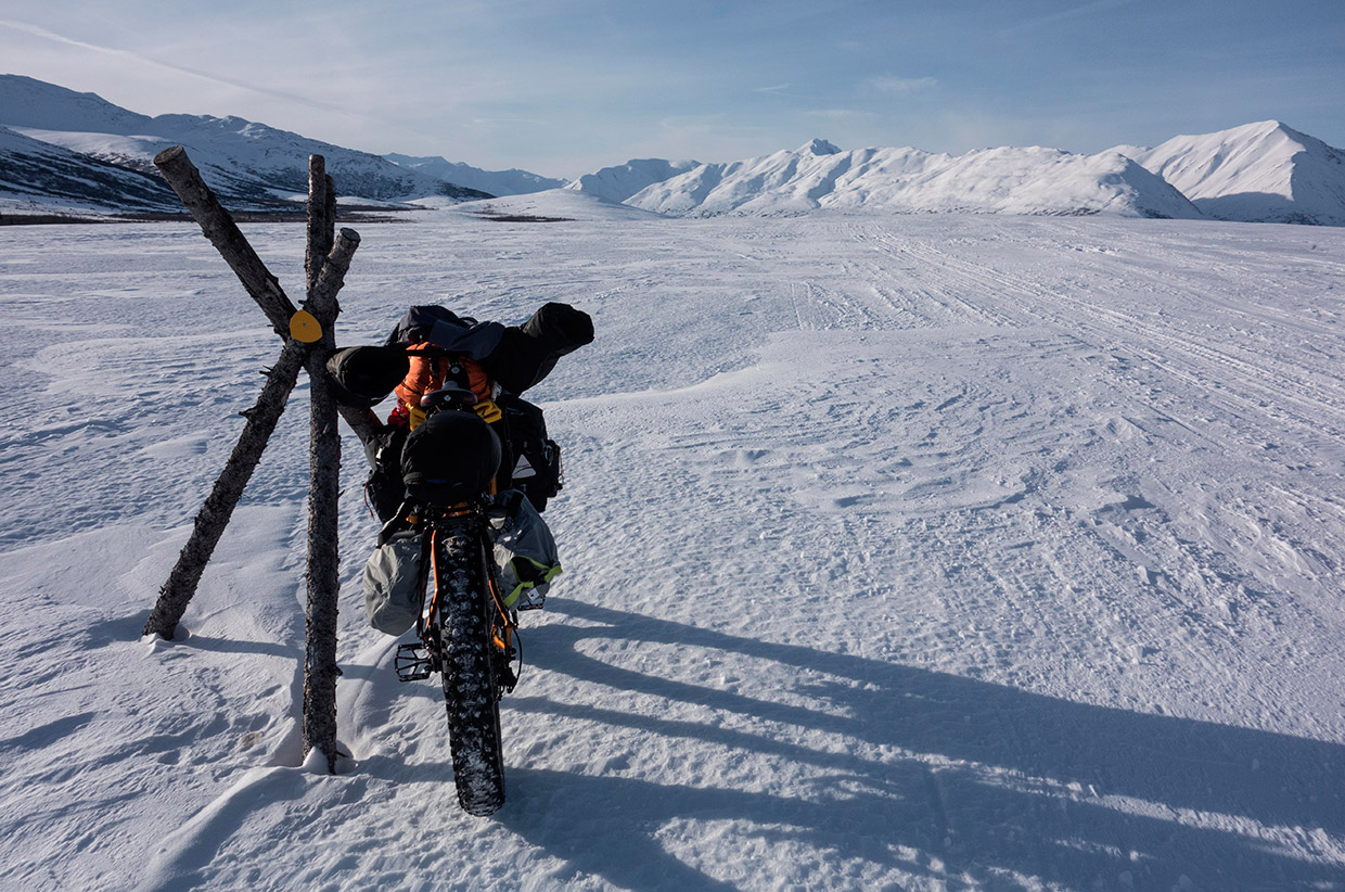
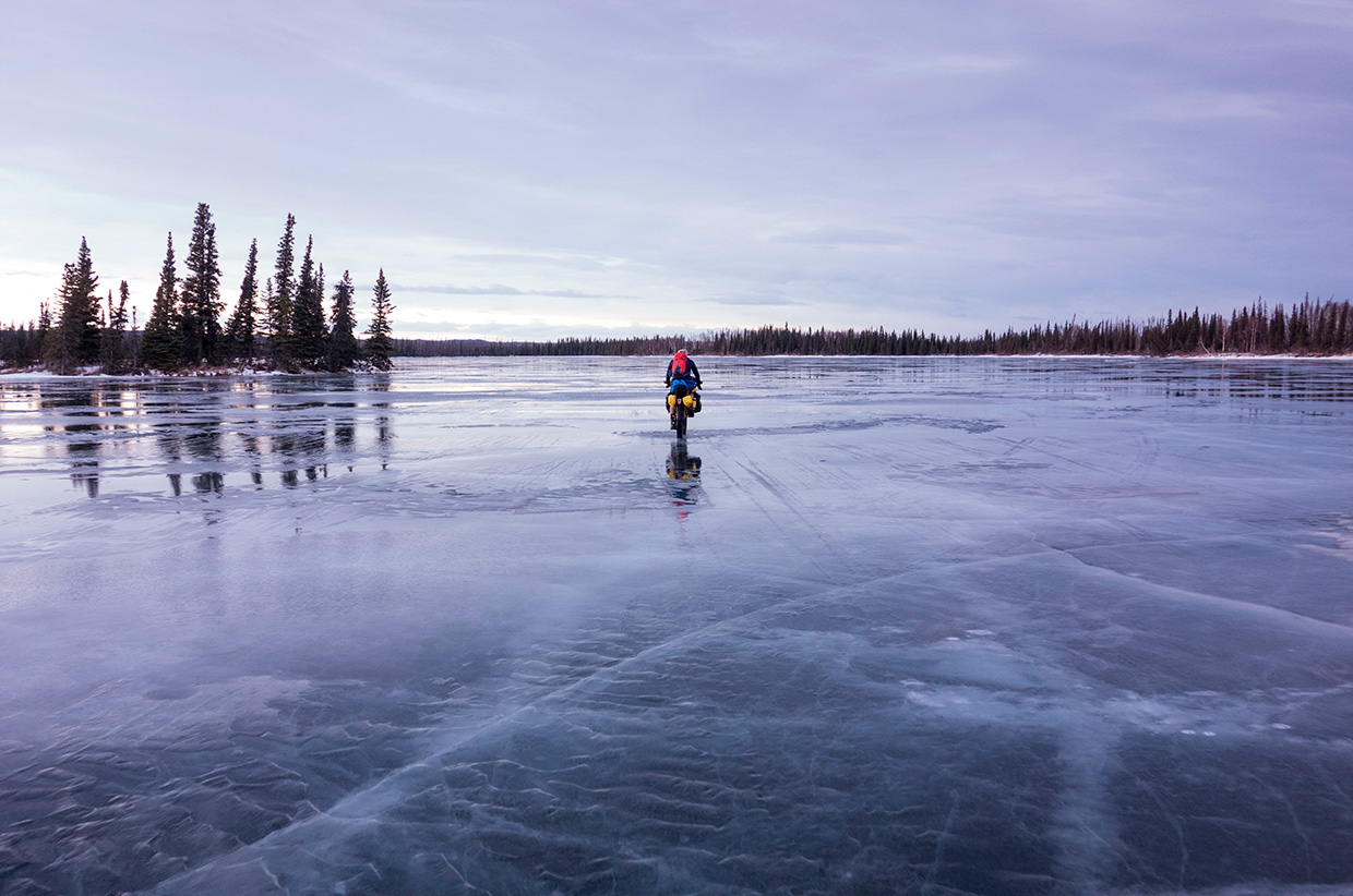
The racers around me carried a variety equipment. All of the bikers had some sort of fat-bike – a four-inch-tyred mountain bike that looks like a cartoon. The massive tyres work like snow shoes for bikes – providing floatation on soft terrain. By lowering the pressure to just a few psi, you can spread your weight over a massive footprint and ride on snow that is too soft to even walk on without punching through.
The rest of the equipment is down to preference. Some use pannier racks; some use soft bags in the frame, on the handlebars, and attached to the seat post. For the 1,000 mile race, I had a large load of equipment including a stove with three days of fuel, an expedition down jacket and trousers, light-weight waders, ice cleats for my boots, goggles and a neoprene face-mask. With all of this, and three days’ worth of food, the bike was heavy. It had everything I needed to keep moving forward in almost any weather.
The initial few hours of the race were hard. With so much distance ahead, it felt like a joke. The very idea that I was going to ride to Nome seemed laughable. The sun was shining, the snow was hard-packed. Racers in the ITI were flying along. I tried to strike a balance between making the best of the conditions and not going too fast. As I had learned on previous occasions, mis-managing sweat can be a big problem. It’s all too easy to ride fast in the sunshine, and sweat out into your clothes. When the sun goes down and the temperature drops 20 degrees, your clothes freeze, robbing them of their insulation.
We spun along the trail with mountains framing the horizon and thin snow crunching under our tyres. I chatted to Jeff Oatley for a while. He had wins in the 350 mile ITI and numerous other winter races. He was a veteran of Race Across America and a rival for the win. The competitiveness of this race is unabashed, but as like-minded individuals who may be forced to save each others’ lives one day, racers share a unique bond.
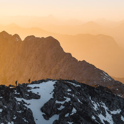
Much of the first 350 miles passed uneventfully. My aim was to stay relatively fresh, keep my body undamaged, and my position in the lead pack. My mood would dip and sway with my blood sugar – brooding thoughts were the first call to start eating again. Like every condition on the trail, if you keep moving forwards, it passes. Where the flat riding ends, The Alaska Range begins. It hulks across the middle of that first 350 miles; a stark focal point.
It had been a warm January in Alaska, and we had heard troubling tales of how the trail might fare through Dalzell Gorge. This part of the trail is put in specifically for the race, descending The Alaska Range into the interior. It crisscrosses the gorge, with ice-bridges put in to take it forward and back over the river. This year, the ground was bare earth with a faint dusting of snow. The bridges were suspect. And the speed for bikers was high. Coming down the trail, I had split-seconds to judge the sturdiness of ice-slabs. Sometimes they would creak under my tyres. Parts of them had collapsed, revealing the running water underneath. High stakes if things went wrong, but it was our gateway to interior Alaska.

So I said my goodbyes and left. It was unseasonably warm. I rolled my boots down in an attempt to keep my feet from sweating too much. As with other clothes, sweating during the day risks frostbite by night. I was fidgety on the bike – my mind still indoors at McGrath. I changed the saddle height a bit to move the pressure on my already-painful knees. I lowered the tyre pressure to give me more floatation in the relatively soft snow. I wondered if Jeff and Phil would leave earlier than they’d said.
The fading light made it hard to read the trail. Organising gear is one of the most important skills out here. Like all of my essential kit, I could put my hand on my head-torch with my eyes shut. So, I tried to preserve batteries by not using it yet. Half of my mind was thinking about dinner, and half of it was watching the lonely silhouettes of Ophir’s mining paraphernalia. Suddenly, I was flipped over the handlebars. The trail had widened, the snow-mobiles had spread out, and they had left little strips of unpacked trail in-between – one of which, I had just blundered into.
The lights of the cabin at Ophir were just what I needed to see. Two volunteers for the dog race had decided to come out early. They immediately offered me hot food, beer, and even a bed for the night. Mindful of the following riders, I declined the beer and the bed. For every moment of comfort in the ITI, there is a voice in the back of your mind; an imperative to keep moving, to take as long as you need, but no longer. Despite the warmth inside and the dark outside, that voice pushed me on, to the longest uninhabited stretch of the route.
It is 170 miles from the cabin at Ophir to the village of Ruby. The names along the way tell the story: Poorman Creek, Cripple, Wolfskill Slew. Sparse trees and unbroken wilderness from forest fires are all you can see until the mining road on the final few miles.
I tried to push on, but the inexorable tipping point came. How much sleep you dare to take, and when you choose to take it, is part of race strategy. Exhausted, my bike was taking more meanders around the narrow trail. Increasingly, I was stopping for no good reason. It was time to sleep and make better progress in the morning.
I stomped down enough snow off the trail to make an area to sleep in. I inflated my sleeping mat, and unfurled my sleeping bag. I was working with thin liner gloves and, although warmer than usual, it was still necessary to warm my hands under my arms for a moment before continuing. I had some warm water left from Ophir, so I put both water bottles in the sleeping bag to stop them from freezing overnight. No need to set up a stove tonight. I put a bag of food within reach of my sleeping bag for breakfast, brushed my teeth, and settled down to sleep.
Rivers and swamps tested my patience with flat, straight riding. The Kuskokwim Mountains drew closer, with confusing perspective: big and far away, or small and not that far? Now, there was only the crunch of snow, insidious climbing, and the tempering of effort to control my body heat.
In the long afternoon along The Kaltag Portage, the hills started to flatten out. The new Old Woman Cabin, so different to my experience of it in 2011, was a place to add a few more clothes: the sun was beginning to outrun my westward progress. A single path reared up ahead, and comfortable-looking tundra carpeted the edges of the trail. I wanted to make Unalakleet, but even the most optimistic estimate would have me arriving in the middle of the night. Hitting towns at night was no better than riding through any other empty place, so I set my aim to be there for breakfast – well-rested, in time to pick up the supplies that I had posted there, and ready to move on quickly. The comfy-looking tundra was actually frozen hard, so I rode on into the dark looking for some smoother ground.
I started to become withdrawn. Legs turned, but my mind did not. The trail started crossing rivers. On one, I had amassed too little momentum and power in my attempt to get up a riverbank, and toppled back with the bike landing on me. Exposed wood, splintered by the passing of snow-mobiles, provided a harsh landing with an aroma of pine. I wanted to stay right there where I fell; exhausted, nearly asleep.
The trail from Shaktoolik to Koyuk is an iconic and dangerous part of the route. It crosses the sea ice of Norton Sound; which can be precariously thin. Sometimes there are even holes, covered by snow and almost indistinguishable from the safe path. Winds rip across the ice and there are almost no natural navigation cues – just wooden stakes put out to mark the race route. A snow-mobile had already gone through the ice this year, so I had no hesitation in taking a rest on its edge, and facing the challenge by day.
In the morning, I covered up every inch of my body before I rode out. When I stopped to eat and drink, I had to turn away from the wind, remove my face-mask, and do the business before the wind took all sensation and dexterity from my hands. Mile by mile, progress was good. Around ten miles out of Koyuk, one stake-marker stood alone. The sea ice had overflowed – water had been pushed up through the ice. By the time I reached it, this water had frozen, but it had taken the trail markers and the snow-mobile tracks with it. I guessed which way to go from the last stake. Riding the slick, newly formed ice was treacherous. No markers and no tracks. I made my way back to the last stake and looked again. Still nothing.
With no marked passage, all I could do was use my GPS to aim for Koyuk and hope. With so much slick ice, and no studs on my tyres, I attached the cleats to my boots for some traction. I tried to read the ice with uneducated eyes. The slickest surfaces threw me down for lack of grip. Soft snow broke under my weight, forcing me to a trudge. On foot, the deeper snow pulled the ice cleats from my boots. After a number of return trips to retrieve the cleats, I added straps to them, holding them firm.
It felt like an eternity. I was always tense, gnawed by doubt. Eventually, I picked up a snow-mobile track across crusty snow. At full speed and maximum effort, I could keep the bike up on the crust without punching through. More tracks came in. Joining, leaving, criss-crossing. I was getting closer. Finally, a wooden stake and a motorway of mashed up snow revealed the return of the main trail.
Local information is often key to safety as you move down the trail. I was told to be careful of open water heading out of town; and not to follow the Iron Dog trail markers over the edge of the ice, but try to find the local snow-mobile route over the land. In the pre-dawn darkness, and with the vaguest of directions, I followed the edge of the village, searching for a likely looking trail. I read stories into some of the tracks on the ground, hoping that they were going my way. There were occasional dismounts, eerily quiet passages over bare ice, but eventually more snow-mobile tracks joined my route. I seemed to have found my way.
White Mountain is 70 trail miles from Nome, and home to Joanna Wassillie, who welcomes racers into her house, departing trail news and warming us with her hospitality. It hit me the moment I arrived and felt too much like coming home. It was a chance to relax and be ready for the final ride. A chance to chat and hear more about life in the village.
The final stretch can be hard on tired legs, so I left White Mountain just before dawn, hoping to arrive in Nome in daylight. I hit those first hills at pace. All the way to the coast, they just kept coming. There was little wind and the trail was packed down hard – I wanted to make the best of it. The view from each hill was the same: more snow-covered hills. Nothing else interrupted the endless crunch of my tyres over the snow, until I caught sight of the coast. Beaches, small bays, and a long spit of land stretched as far as I could see. The promise of the finish.
Topcock Mushers’ Cabin sits at the bottom of the final hill. It is where mushers put on their extra layers of clothing to prepare for the coastal winds. Winds over 50 mph are pretty common around here, battering riders and mushers alike, pushing down from the mountains, driving you towards the sea. That day, I arrived before the winds had picked up, so no face-mask was needed. I kept on, to make as much ground as I could before they came.
The snow had been blown clear of the trail along the coast leaving a stark choice: ride over frozen, ridged ground, or along the ice on the edges of frozen lagoons. I chose a silent, nervy, but fast trip over the ice. I tried to keep the tension inside my head to keep it from spreading down to my muscles. The pedalling had to be smooth; any steering had to be gentle. The side-wind mustered an insistent push towards the sea, but with little traction, I couldn’t steer against it. I had to let it drift me off-course. I would pick patches of roughed-up ice to turn into the wind and take back some ground before coming out onto the slick stuff and slowly being forced across again.
Safety Roadhouse is the last stop before Nome. I fantasised about a Coke and some chips to fuel the final run around Cape Nome and into town. When I hit an actual road, the excitement was short-lived. Most of the road was covered in black ice – completely unusable without studded tyres. Riding on the fringes, I made slow progress.
When I saw Safety, my heart sunk. Doors closed, no smoke from the flue, no snow mobiles outside. I was too early. Safety would open for the sled dogs, but our bike race was running so fast that they hadn’t opened yet. The best I could manage was to take shelter from the wind. I ate some tortilla chips and home-made fudge from my supplies. At least I would be moving along the trail again soon.
As I ate, I saw Cape Nome clearly in the afternoon sun, but its foot was shrouded in white. The wind was coming. It was already on the Cape and looked to be ferocious at ground-level. I hurried back onto the bike, trying to gobble up as many easy miles as I could before things went to hell.
Fishing camps and summerhouses were silent clues that Nome was getting closer. Their dwellers’ lives were a season away, and not a soul interrupted my journey. The ploughed road made for pretty decent travel. On either side, snow was piled up a metre high. It was no surprise when the wind came, but it came hard. Trapped between the ploughed snow on the sides of the road, I frequently had to steer away from the seaward side. Often, grip eluded me and I fell. The trick was to get your hands away from the bars before you hit the ground, avoiding a trapped finger. Resist the temptation to brace with your hands, avoiding a broken wrist. Just hit the ground like a sack of potatoes, get up, and go again. The wind was stinging my face and new bruises gathered on top of old. I looked at the time and put on my goggles and facemask. Even walking, I could get to Nome before I had to sleep. The only question was how much these last few miles would hurt.
I tried the road first, giving up because of the wind. Then I tried the snow just outside it – a centimetre of crust sat on top where the warmth of the sun had melted it, and it had refrozen multiple times. I was climbing towards the Cape now but, if I rode at maximum effort, I could keep the bike floating on the crust for at least 100 metres at a time. Each burst of speed would end in one of two ways. Either the front wheel would sink and I would go ever the bars, or the back wheel would sink and I would have to find even more effort to power the bike out, or grind to a halt. Nothing was easy.
On Front Street, Nome, there was no finish line. No party, and no supporters. When I rolled to a halt, I looked around: no-one to share in the moment. I took a note of the time, and then a room in the nearest hotel. I phoned my wife, and I phoned the race organisers. The Iditarod Trail Invitational was over for me with the disappointment of coming second to Jeff Oatley. I had to raise my hand to the stronger, more experienced rider. One of only a few people who could truly understand the last 11 days.
Aidan would like to thank Emily, his family and friends for putting up with his training obsession. Thanks also to the following sponsors: Singular Cycles, Wildcat Gear, USE/Exposure, Just Riding Along, Middleburn, Gore Bike Wear, and Maxxis
Website: www.aidanharding.com
Twitter: @AidanHarding
Instagram: aidan.harding
Photography by RJSauer
Website: monologblog.com
Instagram: arjsauer