A Short Walk in the Other Afghanistan
Jan Bakker
It’s over 40 degrees celsius in Dushanbe, the capital of Tajikistan, and the start of the very long journey to the valley where the Hindukush and the Pamirs meet: The Wakhan Corridor. For the next 20 hours we will be stuck in a crammed SUV, on our way to the border town of Ishkashim. The spectacular route makes up for it. The bone-rattling road, a section of the infamous ‘Pamir Highway’, follows the Panj River through deep gorges and lush green river banks. On the opposite side of the river is Afghanistan.
The Wakhan Corridor is a 400km long strip of land in the northeast of Afghanistan, created during the “Great Game” era. At the end of the 19th century, when the frontiers of the British and Russian Empires came too close for comfort, both parties agreed on a buffer zone, guarded by two formidable mountain ranges. The same immunity to warfare still applies: the Wakhan has been virtually untouched by the wars that have torn the country for decades.
Contrary to our expectations we get a warm welcome at the Afghan border crossing. The officials even offer to call us a taxi! Nevertheless, entering Afghanistan feels strange, not right. The discouraging words from our beloved ones back home echo through our minds. Is this trip a mistake? In Afghan Ishkashim we need to take care of the bureaucratic hurdles. Four permits are needed to make it all the way up the Little Pamir Plateau, 300km eastbound. The permits are handwritten; the procedure takes a full morning. After drinking endless cups of tea we receive our travel permissions.
Our Toyota Landcruiser works its way through the wide, dusty Wakhan Valley that doesn’t seem to have an end. The monsoon rains have ravaged large parts of Northern Pakistan just recently, and the Hindukush is still draining the huge amounts of precipitation. There are no bridges to cross the raging side-rivers. Our driver claims that it this is business as usual, and perhaps it is. He finds a spot that he classifies as shallow (we are not so sure) and steps on the accelerator. The ice-cold water climbs up the doors but with some slipping and sliding we manage to get across to the other side.
Just before darkness sets in it becomes clear our vehicle has reached the end of its journey. The road is gone, washed away by the roaring water of the Wakhan River. We will have to trek the remaining 90km in to the trailhead at Sarhad-e-Broghil. It’s harvest time in the Wakhan Corridor. There’s lots of activity in and around the villages and we start to feel happy about our misfortune. Our slow pace of travelling allows us a rare insight in the daily lives in this forgotten part of Afghanistan.
Wedged in between the giants of the Hindukush and the Pamir Mountains lies one of the world’s most remote adventure playgrounds. This is the Wakhan Corridor, a panhandle-shaped strip of land in the far Northeastern corner of Afghanistan.
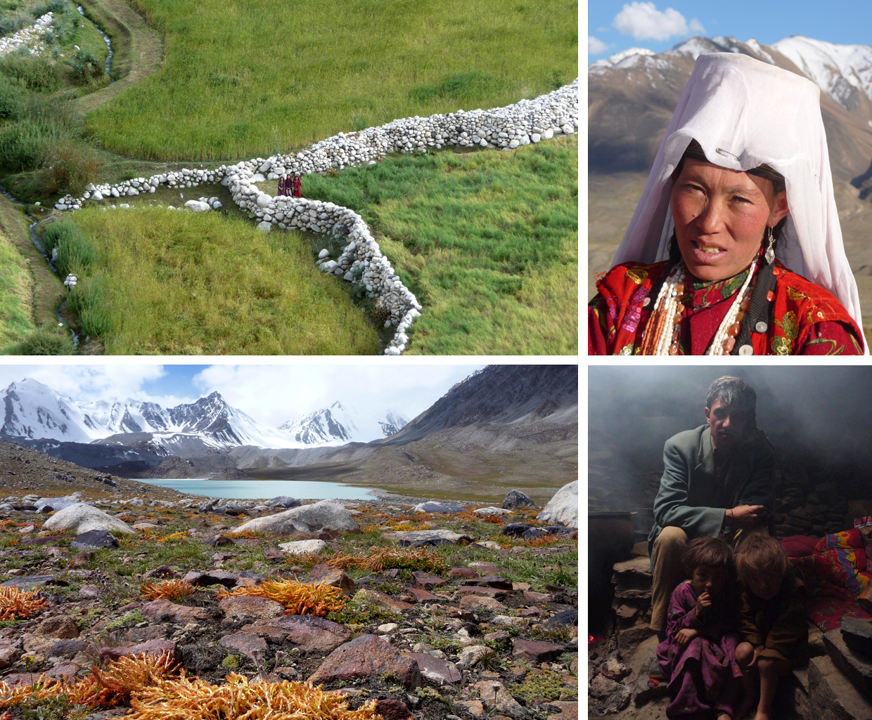
We hand over our handwritten permission to the village chief at the yurt settlement of Khachigosh, the gateway to Little Pamir. It is a mystery why they call it “Little”; the altitude is over 4,000m, on the north side are the rolling, multi-coloured mountains of the Pamirs that mark the border with Tajikistan. The southern end is dominated by the jagged, razor-sharp summits of the Hindukush. And at the very end of the immense plateau, five days walking to the east, loom the giant mountains of the Xinjiang Province in China.
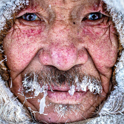
It takes us three days to reach Sarhad-e-Broghil (3,265m above sea level). It feels like a Shangri-La. Colourful fields with rapeseed and barley, fringed by tall poplar trees, surround the village. The women in red robes who work the land and the glaciated peaks that reach over 6,000m make this picture a feast for the eyes. However, the reality in winter could not be further from paradise. Temperatures plummet down to minus 30 degrees Celsius and huge snow levels block the only road out. Winter sets in during October and is there to stay until April. It’s a race against the clock to get the village prepared for seven months of complete isolation from the rest of the country. Life here is tough.
The beckoning mountains to the east seem impenetrable. We can’t see any obvious trail or pass, but Otembik ensures us there is a way through. Our yak doesn’t look very impressed with the 50kg we just tied to its back. But this hairy cousin of the Highland Cow is the perfect pack animal for high altitude expeditions. It can carry 100kg+ loads up to 5,500m. Besides that, a yak is just a very cool and photogenic travel companion! As the sun rises, our mini-caravan sets off to the wild and windswept plains of the Little Pamir Plateau.
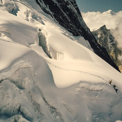
The terrain is easier than expected. This well-trodden trail has been used as a trading route for centuries. In fact, this is the exact same route that Marco Polo used on his way to China in the 13th century. We set our camps in spectacular places that are marked as villages on the map but in reality are little more than ruins. After days of wading through ice-cold rivers and and the howling bad-e Wakhan (the 120-days wind) we reach the barren and empty high-altitude plateau.
We hand over our handwritten permission to the village chief at the yurt settlement of Khachigosh, the gateway to Little Pamir. It is a mystery why they call it “Little”; the altitude is over 4,000m, on the north side are the rolling, multi-coloured mountains of the Pamirs that mark the border with Tajikistan. The southern end is dominated by the jagged, razor-sharp summits of the Hindukush. And at the very end of the immense plateau, five days walking to the east, loom the giant mountains of the Xinjiang Province in China.
An ethnic group of around 2000 Kyrgyz nomads roam on what they call Bam-I-Dunya, or Roof of the World. Life is extremely rough. The only available fuel to heat the yurts in the brutal winters is dried yak dung. Due to the lack of access to medical facilities and endemic malnutrition, the Wakhan Corridor has one of the highest maternal mortality rates in the world (160 of every 1000 babies do not survive birth). In 1978 the majority of the Kyrgyz population fled to Eastern Turkey, locally known as the “Last Exodus”.

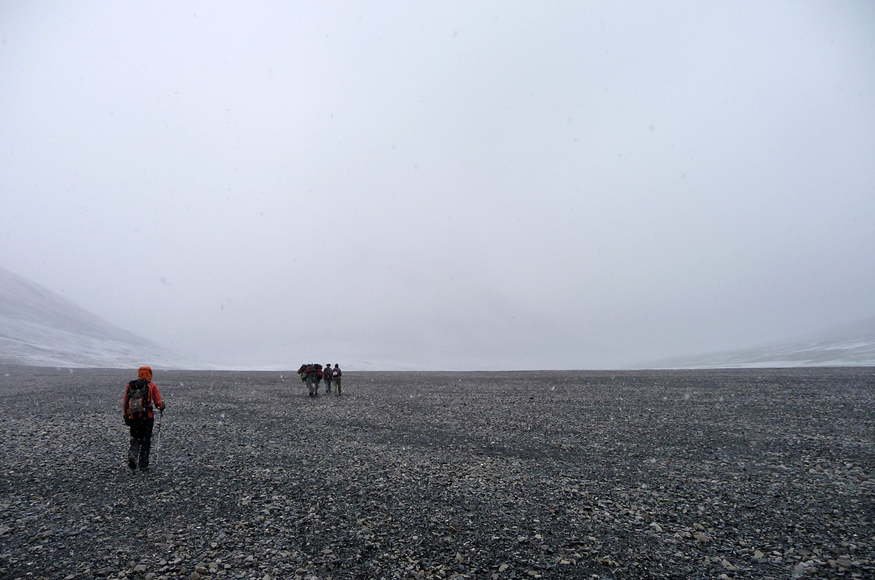
The next days will be hard work. First we have to cross the snowbound 4,887m high Uween-e-Sar Pass. Immediately after that we’ll ascend the Kotel-e-Qarabel Pass which, at 4,820m, is still higher than any summit in the Alps. It’s extraordinary to see the local shepherds actually living in this extreme environment with little more than a tarp and the clothes they are wearing. We’re heading for the highest camp of the trek, a plateau with azure mountain lakes at 4,600m. Our 1980’s Russian military map doesn’t show any trails leading to it. Both Otembik and Safdar have never been up to this territory either. However, four hours later we pitch our tent in probably one of the most spectacular mountain sceneries I have ever witnessed.
The prolonged stay at altitude is wearing us down. The nights have been bitterly cold and we completely lost our appetite. It’s time to return to Sarhad-e-Broghil, where a steamy hot spring awaits us. We hope the road is open again so we can cross the border back into Tajikistan. Inshallah.

Jan Bakker was born in a Dutch village below sea level. After seeing his first mountain at age 16 (!), he has been visiting remote mountain regions throughout the world ever since. He recently finished the first trekking guidebook to Tajikistan which includes this trek in the Afghan Wakhan Corridor. This summer he returned to the Wakhan to lead a high altitude trek for Secret Compass. Currently Jan is working on various projects promoting outdoor sports and adventure travel in Tunisia.
Blog: trekkinginthepamirs.com
Web: janbakker.photoshelter.com
Email: [email protected]